Mālō nī!
Hakilikili ma toe kikila ki na koa ma na ata o Tokelau.
Showing 2477 items from Tokelau
Filter by
-

 Tagata Pasifika - First EpisodeNZ On ScreenVideo Cook Islands Fiji Niue Samoa Tokelau Online
 -
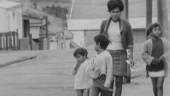
 Children of the MigrationNZ On ScreenVideo Cook Islands Fiji Niue Samoa Tokelau Online
 -
 Dawn RaidsNZ On ScreenVideo Samoa Tokelau Online
 -
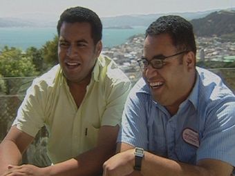 Long Lost SonsNZ On ScreenVideo Tokelau Online
 -

 Boys survive 50 days lost at seaAustralian Broadcasting CorporationAudio Tokelau Online
 -
 Samoa Jumping the International Date LineAustralian Broadcasting CorporationAudio Samoa Tokelau Online
 -
People of Tokelau want better servicesAustralian Broadcasting CorporationAudio Tokelau Online
-
 An assessment of the skipjack and baitfish resources of Tokelau.National Library of AustraliaText Tokelau
 -
Wellington Māori PerformancesNgā Taonga Sound & VisionAudio Fiji Tokelau Not online
-
TAGATA O TE MOANA 25/03/2017Ngā Taonga Sound & VisionAudio Niue Tokelau Not online
-
RNZ NATIONAL. CHECKPOINT 14/07/2020Ngā Taonga Sound & VisionAudio Cook Islands Niue Tokelau Not online
-
SPORT’S RESULTS. 4/05/1991Ngā Taonga Sound & VisionAudio Niue Tokelau Not online
Results per page
Tokelau
Welcome and warm Pasifik greetings
The information on this site has been gathered from our content partners.
The names, terms, and labels that we present on the site may contain images or voices of deceased persons and may also reflect the bias, norms, and perspective of the period of time in which they were created. We accept that these may not be appropriate today.
If you have any concerns or questions about an item, please contact us.